Trip Planning Tools
A fairly constant theme in our home is trip planning. Both of us love to look at maps and start picking out places we want to travel to. Those places are usually lakes because let’s be honest, a good place to fish is always our goal. You can catch smallmouth bass in so many lakes in Ontario, but each lake provides its own unique experience, and that’s what makes fishing so much fun. As we found ourselves working through some trip planning this morning, for a really awesome summer trip that we’re not going to mention quite yet, I was looking at all the different resources we use and realizing how much they help us in figuring out a trip.
Here are some of our favourite tools:
GOOGLE MAPS
Duh! Yes, I know, everyone knows this, but it still bears mentioning. We usually have a final destination in mind for our trip before heading to Google Maps, but this is where we figured out time and distance calculations. We figure rough ideas of how far we want to drive every day and start narrowing down stopover points. This gives us the rough outline of the trip as we go back-and-forth between this and other tools. Once we have everything else finalized we come back here to plan the final route.
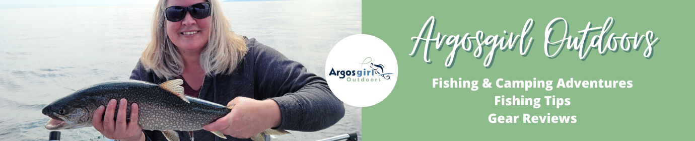
BACKROAD MAPBOOKS (BRMB) APP
This app more than pays for itself and is my go-to for all trip planning. It covers all of Canada and has so many useful layers in it. When I’m browsing for a lake to visit, I’ll turn on the fishing layer and the crown land layer and start exploring. If there are several lakes in an area, with what looks like access trails (I use the trail layer and the satellite imagery to sort this out), then I drop a waypoint in the area and do a bit more research. This app shows you fishing opportunities, campgrounds, hiking trails, snowmobile trails, and so much more. There’s a free version but I highly recommend buying the PRO version.
ONTARIO CROWN LAND USE POLICY ATLAS
In Ontario we’re blessed with an abundance of crown land (at least outside of Southern Ontario). Of course, knowing what is crown land, and what is private land, can be tricky, so here’s the place to figure it out. Different areas of crown land can have different uses, so you need to understanding what you’re looking at when you use the atlas. Not all areas are available for camping. There are many great YouTube videos to you how to use the crown land atlas and how to understand the land use for each area. I always check here to confirm that an area we’re heading to is actually crown land.
FISH ON-LINE
Fish ON-Line is another Ontario resource and it can help you find lakes with certain species of fish, or you search a particular lake and find out what fish species there are records for in that lake. It also has stocking history and links to the fishing regulations. I have to admit, the fish records on this website often don’t match up with the fish records in the BRMB app, so always do a little extra googling to figure out what might be in there.
ONTARIO FISHING REGULATIONS
Know if the waterbody you’re heading to is open or closed, what the catch limits are, or if it has special regs. It’s hard to find the print copies these days, so do the research ahead of time, but also download it to your phone for offline use, or print off the regs for the zone you will be in.
PAPER MAPS
Always have a paper map for your trip. You can print maps off of Google but we like to have actual paper maps or mapbooks that cover a larger area (in case we need to change course). Check that your paper maps agree with your online maps, and make edits if needed. Having a paper map saves your butt if you forgot to download offline maps before you lost service. Backroad Mapbooks are also awesome for having a physical option.
Of course, we do a lot of googling about the areas we want to go, look for guide books for the area, search social media, and see what other information we can come up with. Trip planning is great fun and there are so many amazing resources out there to help you come up with a route. Expect the unexpected and have some back-up plans sketched out, but get out there and explore!
argosgirl
Latest posts by argosgirl (see all)
- Molly - March 11, 2026
- First Ice at Island Lake - January 4, 2026
- I Used To Hate Winter - January 3, 2026

For the past 20 years I’ve explained to anyone interested (and many who were not) that one of my most important fishing resources are BRMB and later on Google Earth satellite view.
Frequently Google Maps doesn’t show smaller water bodies and often shows non-existing or seasonal bodies.
I prefer the satellite view over GM because photos don’t lie and you have the ability to scroll through the historical imagery.
Searching a forested area is far easier when an image is selected when the trees are bare. Even the smallest game trail can sand out.
Absolutely, the satellite view is best and probably what I use most! Now that I have the BRMB app I tend to use that for my satellite imagery because I can switch back and forth between layers so easily, but it doesn’t have the historical imagery like Google Earth. I’ll have to make better use of that historical imagery! I’ve found in the past that it really helps to pick out different features when you can scroll through the years and find images from different seasons. Thanks for reminding me of that and for reading the post!